 The MBTA's Green Line in Boston is primarily light rail; the MBTA acknowledges this in their publications. Thus, in extending this line it should be applied to the needs which 'light' rail best suits, and not forced into the role of a heavy rapid rail line: que Jerry Herman.
In this alternative proposal to extend the Green Line, it will be easily accessible, cover a wide area and traverse along critical commercial and business corridors. It will allow the elimination of several MBTA bus routes which the official GLX proposal does not do. It will utilize modern technology to trigger traffic signals for unimpeded movement along existing right of ways, eliminating cross traffic inhibitors. And, this implementation will not reduce existing road capacity for other vehicles, i.e. no traffic lane elimination.
Because it goes where people want to be, either their jobs, shopping, professional services, entertainment, etc. it is superior to the current GLX proposal. It also is closer to where people live, and could prove much more capable in attracting new MBTA patrons, than a GLX dependent upon bus connections. And yet, this tram (light rail) proposal differs significantly from the current implementation of the Green Line in Boston. The tram service will have fewer stops than the 'B', 'C' and 'E' branches of the Green Line, but more stops than a typical heavy rail line, and certainly more than the current GLX proposal.
This proposal is that stops should be no less than 3 and no more than 4 per mile of service. At an average of 3.5 stops per mile, the service will be greatly accessible while offering swift movement to riders, as traffic light stops are eliminated.
Light Rail, As It Was Meant To Be
Almost every public street in Boston and surrounding towns are under utilized for transit, having nearly half of their paved portions used for the parking of private vehicles. However, the public right-of-way exists to provide for the free 'movement' of the public, not the storage, temporary or otherwise, of vehicles. When an acknowledged public transit need arises for its use, there should be no question as to precedence, though where appropriate and feasible mitigating measures should be taken and will be here. Part of that mitigation is that the system will be largely single track routed.
The typical rail line configuration is to run two tracks along the same corridor, handling rail traffic in each direction. While common, it is NOT a functional necessity to have an inbound and an outbound line side by side. For heavy rail, it is cost effective to have the two together, due to the extent of infrastructure involved, but light rail needs little more than a stretch of sidewalk to deposit or pickup passengers. This added flexibility allows us to more easily spread the 'love'.
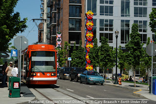 |
| Single tracking in Portland. |
In Boston, the occurrence of parallel roadways is infrequent, particularly primary or commercial streets, but this condition doesn't doom us. In fact, it is fortuitous, as a workable pattern results in a better distribution of benefits to the people of Somerville, at no extra expense.
The average urban rail system would have one person only two blocks from a two way line while another person is ten blocks from the same line. Splitting the inbound and outbound lines not only makes it easier to implement, it evens out the accessibility. Being two blocks away from an 'outbound' rail line in the morning when needing to get 'inbound' doesn't appear advantageous, but it is better than being ten blocks from any line. And, it gets better.
In a heavily populated city like Boston, there is no single transit solution. If you've read the other pages of this site you'll know the rationale and proposal to branch the Orange Line 'heavy' rail into Somerville and Medford. That appropriate and cost effective implementation will increase the ability of light rail to serve a wider community. The map below shows this heavy rail and light rail proposal.
Though it appears the Green Line divides into four branches here, it is only two. The northern most branch, I'll call 'H' for Hillside, initially runs along the same route that the original GLX (Green Line Extension) intended to use. It veers from the trunk line into an old rail right of way which parallels Highway 28, runs under the Fitchburg Commuter Line then adjoins the tracks currently used by the Lowell Commuter Line. However, this implementation of the Green Line 'expansion' uses this corridor only briefly, up to where it shares a station, Prospect Hill, with the new Orange Line (West Medford) branch.
Now REMEMBER, once the line leaves the existing rail corridor to run curbside on roadways, it does not forego its ability to move unimpeded. Recall, that triggers will be placed to change traffic signals for approaching trams, and there will only be one tram track (one direction) on each street, thus traffic signal interruption will be minimized. Also, tram stops will be placed on the aft-side of each intersection crossing.
 |
| Davis Square |
The bridge carrying Hwy 28 over the railroad tracks is a truss structure, with a center element dividing the bridge into two equally sized through ways.
The traffic load at that juncture is such that it disallows co-opting a lane in either direction, and the bridge's configuration does not allow downsizing the lanes to fit a single tram way on the bridge. Thus, a single lane bridge for the tram would need to be placed alongside the existing bridge.
From that point, the line runs a few blocks and then turns left onto Broadway. It'll run out Broadway and veer onto Boston Ave. running out to Hillside. On the outbound trip it'll stop at two more Orange Line stations. The inbound begins on the backside of Tufts University, down through Davis Square and a stop at its Red Line station, then down Highland Ave., back to another stop at Prospect Hill Station.
The 'P' Porter Square Branch extends the Lechmere stub, but the elevated portion which now stretches over Highway 28 will be removed and the viaduct portion can be cut back as far as Austin Street. After crossing Austin St., the line will divide and the 'P' tracks will begin to descend; the tracks of the 'H' branch will descend immediately after the outbound 'P' track has passed underneath. This clears the viaducts from the intersection of Highway 28 and Cambridge Street, and the 'P' Green Line will then cross Highway 28 at street level.

As envisioned here, the Lechmere 'Station' stays in the same locale (unlike in the GLX proposal, which puts the station across the roadway/highway and elevates it at a price tag of $112M [$36.4M for the new station and $75.4M for aerial guide-way]), but the physical station will change, as will the land around it. Currently most of the property at the station is used to turn the trains and as a bus port. With this proposal, neither of these functions will be needed at this locale, and thus the remainder of the property could be sold for private development to mitigate the expense of this project, or could be traded/sold to the city of Somerville to use as a landmark park.
The 'P' branch outbound track heads north from Lechmere up Gore and Medford Streets, then left onto Somerville Avenue. It runs through Union Square, then continues on Somerville Avenue out to Porter Square with a stop at the Red Line station. Returning, it runs down Massachusetts Ave. passing the Red Line station at Harvard Square and completes its inbound route down Cambridge Street.
 |
| Union Square |
Those most convenient to an inbound light rail line can do the same in reverse. In this manner, the inconvenience of a change of transit is limited to only one daily trip, and the choice exists to have no transit change. A commuter could either ride a bit farther on the line to incur no transit change, or walk farther to a rail stop, but again this inconvenience is limited to only one of the two commute trips.
The one way routing is advantageous for two other reasons. One is that it allows for retaining right of way space for loading and unloading, which businesses have come to rely upon and which communities have heretofore provided. This function is important also for some residential buildings where private drives are not provided. It could be argued that these are special interest uses of the public right of way and should not hinder advancing public transit, but these are functions to which we've long acquiesced, and in this instance we can reasonably accommodate. Loading and unloading zones will be increased as needed in remaining parking lanes and on side streets.
This routing method also increases the viability of triggering traffic lights for priority passage through roadway intersections. The triggering of lights by rail cars in both directions would present occasional problems for other vehicles.
Why Not Implement Buses In Dedicated Lanes?
 The MBTA's Silver Line Bus rapid transit uses reserved or designated lanes. In its implementation parking lanes have been retained, opting instead to reduce the number of lanes available to other traffic.
 Most of the Silver Line uses the same streets for both inbound and outbound service, making it difficult to co-opt parking lanes for right of way use. Some allowance for loading and unloading areas must be made to residences and businesses long accustomed to the practice of using the public right of way for private uses.
This is a condition which the GLR's Green Line proposal acknowledges and for which it provides, by retaining a lane for parking options along virtually the entire tram route. But, aside from this particular implementation feature, why is a rail based transit option proposed over the seeming flexibility which buses offer?
The most frequent criticism of Bus Rapid Transit is that it is STILL a bus. While the comment itself provides little in the way of rationalization and leaves supporters flummoxed and annoyed, there is more to the comment than just the smell of a deeply rooted bias. When comparing the two modes, the greatest edge the buses have over the rail cars is their purported flexibility. Ironically, that very characteristic also contributes to the transit modes downfall in comparison to rail transit.
A bus's flexibility to be assigned to a different route, or have its route modified, is hardly viewed as an asset to daily riders. It may be seen as a big picture asset to the management of the transit system, but that isn't going to improve someone's ride. On the contrary, 'flexibility' is derived by virtue of the bus having the same basic means of movement and operation as most all other vehicles traveling along the public roadways. And therein lies the rub.
Buses are expected to behave in a similar fashion to other rubber tired vehicles on the roadway. In other words, the driving public does not defer right of way ownership to a bus like they will a rail car. Simply put, buses are expected to stop when impeded by anything, whereas trains, no matter how short their length, are given a relatively wide berth to proceed unimpeded. That doesn't mean that tram and car collisions are non-existent, but they are very rare, and bus and car collisions would be great in number but for the fact that buses are frequently braking for cars which infringe upon their right of way.
Unless a bus has a protected and dedicated right of way (in which case the whole argument of flexibility is moot), as is the case with some underground portions of the Silver Line, it is more likely to be subjected to infringements of its pathway than would be a rail vehicle. These infringements produce disruptions in the ride, whether a bus driver uses steering or breaking in response, those unexpected movements, up, down, side to side, backward or abruptly forward, all add up to what is meant by . . "It's still a bus."
It could be argued that lanes for rail vehicles would befall the same fate, but the public recognizes rails on a roadway as reserving space, more so than simple paint markings, and are more apt to steer clear of a rail vehicle than a bus or truck. Here, also, the light rail lane will run along the curb, not along a parking lane, and the rail bed can be raised slightly, paved differently or be separated from the adjacent lanes by a narrow concrete curb.
The fixed rails needed for trams are in fact a reassuring characteristic for both tram riders and drivers of other vehicles on the road. A rail vehicle is seen as more predictable in its movement, whereas buses have no assured path, are viewed with equal status as to road rights, and are expected to stop as any other road vehicle when impeded.
Costs to Implement This Green Line Proposal
As there are no current examples for this type of implementation, any costs speculation would lack sufficient grounds. Unfortunately, virtually all of the current 'light' rail implementations in the U.S. have turned into Dr. Frankenstein's monster. Civic and rail transit supporters, and those who profit from such, have made use of the 'light' label to pull the wool over taxpayers' eyes, while they proceed to build all of the infrastructure which a heavy rail system requires. This proposal goes in the opposite direction, seeking to revert to the true meaning of light rail, and thus making use of existing public infrastructure.
The capital costs lies primarily in embedding tracks on existing roadways, running power lines for the overhead power supply, installing traffic signal control, and the purchase of rolling stock. Additional expenses to upgrade tram stops, provide for safety barriers where needed, etc. will surely arise.
 On the subject of finances, the heretofore process of Green Line 'tram' riders tendering fares as they board has interfered with transit times. A suitable means of fare retrieval and/or ticket validation must be implemented.
 Proof of purchase is a fare verification method widely used on similar transit systems all over the world, where the tedious inspection of every rider's fare credentials are replaced by occasional and random checks to encourage compliance by the vast majority of riders. The absence of proof of purchase incurs a stiff penalty and fare payment.
Automated fare boxes can be installed at each tram stop to facilitate an ease of purchasing single ticket fares or multi-travel passes, removing the handling of fare transactions from tram operators as well as the validation of tickets. The random checking of tickets and passes will be handled by personnel who board tram cars sporadically throughout the system.